NEW YORK (WABC) A powerful winter storm is set to slam New York City and the Tri-State area Sunday night into Monday, bringing blizzard conditions, dangerous travel, and the potential for widespread power outages.
Eyewitness News Meteorologist Jeff Smith says this could be one of the most significant snowstorms the region has seen in years.
The storm is poised to be the biggest snow-maker to slam the Tri-State area since the storm of January 2016, which was the biggest snowstorm to ever hit NYC on record. The last time we faced a blizzard warning was in March 2017, so this is a rare event. The storm involves the convergence of energy from the Ohio Valley colliding with Gulf and ocean moisture to produce a storm that almost resembles a winter hurricane.
Storm Timeline
Conditions stay quiet Saturday evening, but clouds will thicken overnight. A few rain or snow showers may pop up early Sunday, though temperatures will remain above freezing to start the day.
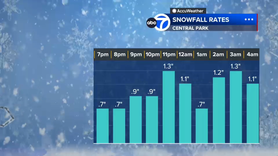
By midday Sunday, visibility will begin dropping as steadier snow develops, especially from New York City south and west. After sunset, temperatures fall and the storm rapidly intensifies offshore, pulling heavy snow bands directly into the region.
Bands of snow could drop at 2 to 3 inches per hour, and in some areas they may sit overhead for hours.